Africa. The Highest Peaks. 1:150 000
Артикул:397907
ISBN:
978-83-61155-28-7
Автор:
-
Год издания:
2012
Издательство:
TerraQuest
Название:
Africa. The Highest Peaks. 1:150 000
Серия:
Trekking Map
Africa. The Highest Peaks. 1:150 000
≈ 2 585,00 руб.
Проверить наличие и купить по самой выгодной цене:
 Узнать цену и купить в Лабиринте
 Узнать цену и купить в My-Shop.ru
 Узнать цену и купить в Читай-Город
 Узнать цену и купить в Book24.ru
 Узнать цену и купить в Буквоед
 Узнать цену и купить в ЛитРес
Товар можно купить в книжных интернет-магазинах, указанных выше.
Цена при переходе на сайт интернет-магазина может отличаться как в большую, так и в меньшую сторону! Указанная цена была актуальна на дату последнего обновления каталога.
Реклама. Рекламодатель ООО "Лабиринт.Ру" / ИНН 7728644571 / Labirint.ru / Erid: 2VtzqwQYCqU
Реклама. Рекламодатель ООО "Магазин книг" / ИНН 9725076959 / My-shop.ru / Erid: AX1LYwMgKUvoDX6y
Реклама. Рекламодатель ООО "Новый Книжный Центр" / ИНН 7710422909 / Chitai-gorod.ru / Erid: 2Vtzqufp5tz
Реклама. Рекламодатель ООО "Новый Книжный Центр" / ИНН 7710422909 / Book24.ru / Erid: 2VtzqvPNRe6
Реклама. Рекламодатель ООО "Новый Книжный Центр" / ИНН 7710422909 / Bookvoed.ru / Erid: LatgBqrsQ
Реклама. Рекламодатель ООО "Литрес" / ИНН 7719571260 / Litres.ru / Erid: 2Vtzqx9kwnn
Реклама. Рекламодатель ООО "Клевер-Медиа-Групп" / ИНН 7717567452 / Clever-media.ru / Erid: LatgBnRdu
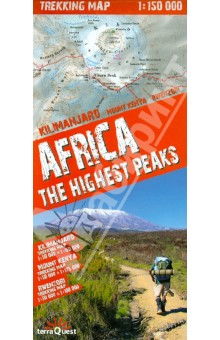
This trekking map includes the African peaks that are most popular among avid mountain hikers: Mount Kilimanjaro, Mount Kenya and the Rwenzori Mountains. It covers areas in Kenya, Tanzania and Uganda. A large-scale map with rich tourism content will allow you to plan your trek in detail. Our maps are laminated and easy to fold (due to the Comfort! Map technology), which makes them exceptionally handy even in the harshest mountain weather. Map characteristics: - rich tourism content (including trekking routes, tourist infrastructure, natural attractions and other sights of tourist interest), - exhaustive topographic information (on the roads, hydrographic features, farmlands, forests, glaciers etc., given in extended nomenclature), - shaded relief, representing the area's three-dimensional topography, - GPS compatibility (WGS84 geographic coordinates), - map legend in six languages: English, German, French, Spanish, Italian and Polish. The title comprises maps of the following regions: - Kilimanjaro National Park and Arusha National Park (1:150 000), - area around the Kibo summit of Mount Kilimanjaro (1:50 000), - volcanic massif of Mount Kenya (1:175 000), - top of Mount Kenya - Batian & Nelion (1:50 000), - Rwenzori Mountains National Park (1:100 000), - highest peaks of the Rwenzori Mountains - Margherita & Alexandra (1:50 000). Map legend in six languages: English, German, French, Spanish, Italian and Polish.
ISBN
978-83-61155-28-7
Автор
-
Год издания
2012
Издательство
TerraQuest
Название
Africa. The Highest Peaks. 1:150 000
Серия
Trekking Map


Что такое Bookкод.ru?

Меню
© 2014-2025 Bookкод.ru | Найди свою скидку, найди свое кодовое слово.